Nightclubs in Birmingham, UK: list of 71 free CSV

How many nightclubs are in Birmingham, UK?

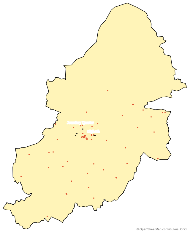
OpenStreetMap lists 71 named nightclubs inside the Birmingham city boundary (267 km²), extract of 7 Nov 2026. 10% of the records list a website and 6% a phone number; 64 named nightclubs have no website on the public record. The biggest clusters are around Digbeth (10).

Examples on the list: 101 Nightclub, Avenue Members Club, Bartley Green Social Club.

Nightclubs in Birmingham at a glance: most are in Digbeth (10), Park Central (9), Rea Valley (7); the busiest streets are Broad Street, Ladywood (3) and Heath Mill Lane, Digbeth (3); records were last edited between Nov 2008 and Oct 2026; 101 Nightclub and Bushwackers list a business phone.

Edited on the map in the 90 days before the extract: 5 records, including The Crossing, Snobs, Tunnel Club, Bushwackers.

71named nightclubs
10%list a website
64no website listed
33neighbourhoods

Data © OpenStreetMap contributors, ODbL, extract of 7 Nov 2026. The CSV is under the same licence.

50 of the 71 nightclubs, A to Z

on the map recordmissing from the recordPicked from 33 neighbourhoods; filter below to search all 71

Showing a sample of 50. Change a filter to search all 71.

Nightclubs in Birmingham, OpenStreetMap extract of 7 Nov 2026.
Business Street and area Website Phone Hours
101 Nightclub 70 Hurst Street, Rea Valley +44 7376 412594
Avenue Members Clubnot edited since 2011 Weoley Castle, no street on record
Bartley Green Social Clubnot edited since 2012 Woodgate, no street on record
Bordesley Labour Club 18 Whitmore Road, Small Heath
Bournbrook and Selly Oak Social Clubnot edited since 2021 13A Hubert Road, Bournbrook
Bromford Bridge Members Clubnot edited since 2017 Hodge Hill, no street on record
Bromford Residents Clubnot edited since 2017 Hodge Hill, no street on record
Brookvale Social Clubnot edited since 2012 Stockland Green, no street on record
Bushwackers 103 Edmund Street, Jewellery Quarter skiddle.com +44 121 236 4994
Chic 28 Horsefair, Park Central
Cotteridge Social Clubnot edited since 2018 Cotteridge, no street on record
E57 Social Clubnot edited since 2021 669 Alcester Road South, Highters Heath
Eastside Jazz Clubnot edited since 2018 Vauxhall, no street on record
Elbow Roomnot edited since 2022 146 High Street, Lozells
Exit 1 Exeter Street, Park Central
Genting Casino Norfolk Road, Harborne
Grange Social Clubnot edited since 2013 11;13 Broad Road, Acocks Green
Harborne Village Social Club 3 Serpentine Road, Harborne
Hay Mills Social Clubnot edited since 2011 Hay Mills, no street on record
HGCC Social Clubnot edited since 2014 Stratford Road, Hall Green
Ivy Leaf Sports & Social Clubnot edited since 2017 2296 Coventry Road, Sheldon
Kings Heath Cricket and Sports Clubnot edited since 2021 247 Alcester Road South, Brandwood End
Kings Norton Ex-Servicemens Clubnot edited since 2018 Cotteridge, no street on record
Lea Hall Sports and Social Clubnot edited since 2011 Kitts Green, no street on record
Maitland Hallnot edited since 2020 Ward End, no street on record
Mama Roux’s 2 Lower Trinity Street, Digbeth mamarouxs.co.uk
Moseley All Services Club 91 Church Road, Moseley
Nightingale Club Kent Street, Rea Valley
O2 Academy Horsefair, Park Central
Pop World Broad Street, Ladywood popworldparty.co.uk
Royal British Legion Worlds End Lane, California
Royal British Legion Kings Heath Memorial Clubnot edited since 2010 Kings Heath, no street on record
Saint Patricks Private Members Clubnot edited since 2014 Winson Green, no street on record
Shard End No 1 Royal British Legion Clubnot edited since 2019 Hurst Lane, Shard End
Shard End Social Clubnot edited since 2011 Shard End, no street on record
Snobs 200 Broad Street, Ladywood snobsnightclub.co.uk +44 121 643 5551
Station Inn Station Road, Stechford
Stirchley United Hazelwell Lane, Stirchley
Suki10c 21 Bordeseley Street, Digbeth social page
The Corenot edited since 2021 Sherlock Street, Rea Valley
The Firs Members Clubnot edited since 2012 Buckland End, no street on record
The Jam Housenot edited since 2015 3;4;5 Saint Paul's Square, Jewellery Quarter
The Mill 29 Lower Trinity Street, Digbeth themilldigbeth.com +44 121 771 4391
Tunnel Club 27 Water Street, Jewellery Quarter
Underground Bournbrook, no street on record
Vaughan's Private Members Clubnot edited since 2014 Stratford Road, Hall Green
Vauxhall Sports and Social Clubnot edited since 2010 Vauxhall, no street on record
West Heath Snooker Clubnot edited since 2012 West Heath, no street on record
Windermere (Moseley) United Services Clubnot edited since 2013 Wake Green, no street on record
Yardley and District Sports and Social Clubnot edited since 2019 Buckland End, no street on record

Download the full CSV (71 rows)

Also as Excel file of the 71 nightclubs, GeoJSON file of the 71 nightclubs, KML file of the 71 nightclubs (maps and spreadsheets; same rows, same licence).

Nightclubs in Birmingham with no website listed

18 of 70 named non-chain nightclubs; 10 below, the rest in the filter or the CSV. 1 more only list a social page (website_is_social_page = yes).

  • 101 Nightclub70 Hurst Street, Rea Valley, phone listed
  • Bordesley Labour Club18 Whitmore Road, Small Heath
  • Chic28 Horsefair, Park Central
  • Genting CasinoNorfolk Road, Harborne
  • Harborne Village Social Club3 Serpentine Road, Harborne
  • Nightingale ClubKent Street, Rea Valley
  • Royal British LegionWorlds End Lane, California
  • Station InnStation Road, Stechford
  • The CrossingDigbeth
  • Tunnel Club27 Water Street, Jewellery Quarter

Where they are

Map of the 71 nightclubs inside the Birmingham boundary; most sit around Digbeth, Park Central, Rea Valley.
website listedno website, or social page only

Busiest streets

  • Broad Street, Ladywood3
  • Heath Mill Lane, Digbeth3

By neighbourhood

Black: website listed.

21 more neighbourhoods in the filter above.

By postcode district

  • B15
  • B95
  • B54
  • B33
  • B142
  • B152
  • B282

Chains and non-chain businesses

1% of the records are branches of a chain or brand; 70 are not.

What the records hold

71 map records.
FieldRecordsShare
Street address3448%
Website (own site)68%
Social or directory page only11%
Phone on file46%
Email on file (not shown)11%
Opening hours34%
Chain or brand branch11%
Edited since January 20241927%

Half the records were last edited in Feb 2020 or later.

Why other sites show a different number

  • Coverage. 71 mapped; Google Maps holds more.
  • Boundary. 267 km² (map); metro searches count more.
  • Names. 1 branches each count once.

Official registers: Food Standards Agency food hygiene rating data (food hygiene ratings of food businesses, published as open data).

Get the complete list with emails, phones and ratings

Businesses to contact, not customer enquiries ("leads" for your own business are a different product).

Suggested source for this list

Google Maps Business Lead & Email Finder

It searches Google Maps for the same category and city and can add emails from each business website.

  • Emails
  • Phone numbers
  • Websites
  • Star ratings
  • Review counts
  • Social profiles
  • no opening hours

One run: about $0.47 to $0.76 for 71 to 360 rows ($0.99 per 1,000 + $0.40 start fee (4 GB run)), plus platform usage ($0.80/hour).

Free plan prices; it includes $5 a month (Apify pricing).

How to run it, step by step

  1. Open Google Maps Business Lead & Email Finder on the Apify Store and sign in or create a free Apify account.
  2. Paste these 3 searches into Search phrases, one per line; the neighbourhood searches catch businesses a citywide search misses.
    1. nightclubs in Birmingham, United Kingdom
    2. nightclubs in Digbeth, Birmingham, United Kingdom
    3. nightclubs in Park Central, Birmingham, United Kingdom
  3. Set Country: United Kingdom; US state: All (nationwide).
  4. Set Maximum leads to 400.
  5. Start it and download the results as CSV or Excel.

Open on the Apify Store What this source returns

Or search by postcode district (7 searches)
  1. nightclubs in B1, Birmingham, United Kingdom
  2. nightclubs in B9, Birmingham, United Kingdom
  3. nightclubs in B5, Birmingham, United Kingdom
  4. nightclubs in B3, Birmingham, United Kingdom
  5. nightclubs in B14, Birmingham, United Kingdom
  6. nightclubs in B15, Birmingham, United Kingdom
  7. nightclubs in B28, Birmingham, United Kingdom

Other ways to build or enrich it

Prices on the Free plan: per 1,000 results plus a start fee per GB of run memory, plus Apify platform usage.
SourceWhat it addsPrice
Google Maps Business Lead Finder with Email & Social Links a second Google Maps route with a different set of columns $0.99 per 1,000 + $0.10/GB start
Yelp Business Search & Review Scraper Yelp listings with ratings and review counts $0.99 per 1,000 + $0.10/GB start
Website Contact Page Email & Phone Crawler reads the websites in the free CSV and returns the emails and phone numbers published there $0.99 per 1,000 + $0.10/GB start
Facebook Business Page Finder by Keyword & City finds the Facebook pages of businesses that have no website $0.99 per 1,000 + $0.10/GB start

Embed this list

Show this free list on your own site: paste the code into any page. It is a small static card with no scripts, cookies or tracking, and it updates when the list does.

Preview the card

The card credits OpenStreetMap contributors (ODbL) and links back to this list on getalistof.com.

Questions

How many nightclubs are there in Birmingham?

At least 71: that is how many OpenStreetMap has inside the Birmingham city boundary, 71 with a name (extract of 7 Nov 2026). 1 are chain branches. Google Maps usually lists more, because more owners add themselves there.

Which part of Birmingham has the most nightclubs?

Digbeth (10), then Park Central (9) and Rea Valley (7); the busiest street is Broad Street, Ladywood (3). 33 neighbourhoods have at least one.

How many nightclubs in Birmingham have no website?

64 of the 71 named nightclubs have no website on their map record; 18 of them are not chain branches. Another 1 list only a social media page as their website.

How do I get phone numbers and emails for nightclubs in Birmingham?

Run Google Maps Business Lead & Email Finder with the search "nightclubs in Birmingham, United Kingdom" plus 2 neighbourhood searches such as "nightclubs in Digbeth, Birmingham, United Kingdom". One run costs about $0.47 to $0.76 ($0.40 start fee (4 GB run) included), plus platform usage, for 71 to 360 rows.

Sources

Using the list: credit OpenStreetMap contributors and keep changed copies under the ODbL; follow the outreach rules where you send. Licence and limits.

Map extract 7 Nov 2026Next refresh after 2 Dec 2026Data © OpenStreetMap contributors, ODbL